


Garmin zūmo® XT2
$599.99 – $1,099.96
THE LIFE OF YOUR RIDE
You need throttle therapy. The Garmin zūmo XT2 motorcycle navigator is your prescription to hit the road, no matter where it goes. The bright 6” display is glove-friendly and packed with features to help you find the perfect motorcycle route.
- The bright 6” display is easy to read, no matter the weather or light conditions.
- Create custom routes with the visual route planner.
- Find the twists and turns with the Garmin Adventurous Routing™ setting.
- See popular moto paths to discover new places to ride.
- Start a group ride to see positions of other riders on the zūmo XT2 display.
- Switch from North America street maps to topographic maps to satellite imagery with just a tap.
Group Ride Radio bundle includes the zūmo XT2 navigator, Group Ride Radio (6,” 8″ and 10”), Group Ride Radio Y-adapter cable and the high-current power cable. This solution allows for location sharing and voice communication with your group.

ULTRABRIGHT DISPLAY
The 6” display is 15% larger than previous models and features an even brighter HD resolution in landscape or portrait mode.

DESIGNED TO ENDURE
Rain? Vibration? Dust? Doesn’t matter. This device is built to withstand all kinds of weather (IPX7) and rough terrain.

VISUAL ROUTE PLANNER
Plan a custom route on the device, or use the Tread app with a compatible smartphone.

SIMPLE MAP SWITCHING
Quickly toggle between on-road maps, topographic maps and BirdsEye Direct Satellite Imagery, so you can always have the perfect map for your ride.

GROUP TRACKING
Use the Tread app on your smartphone and/or zūmo XT2 device to track friends with the Group Ride Mobile feature1. Or use the Group Ride Radio accessory2 (sold separately) and the Group Ride Radio Y-adapter Cable (sold separately) for tracking other zūmo XT2-equipped riders with no cellular coverage needed.

BIRDSEYE DIRECT SATELLITE IMAGERY
Use BirdsEye Direct Satellite Imagery from around the world to help you navigate. Download the maps directly to your device via Wi-Fi® technology3. No annual subscription required.
NAVIGATION
![]()
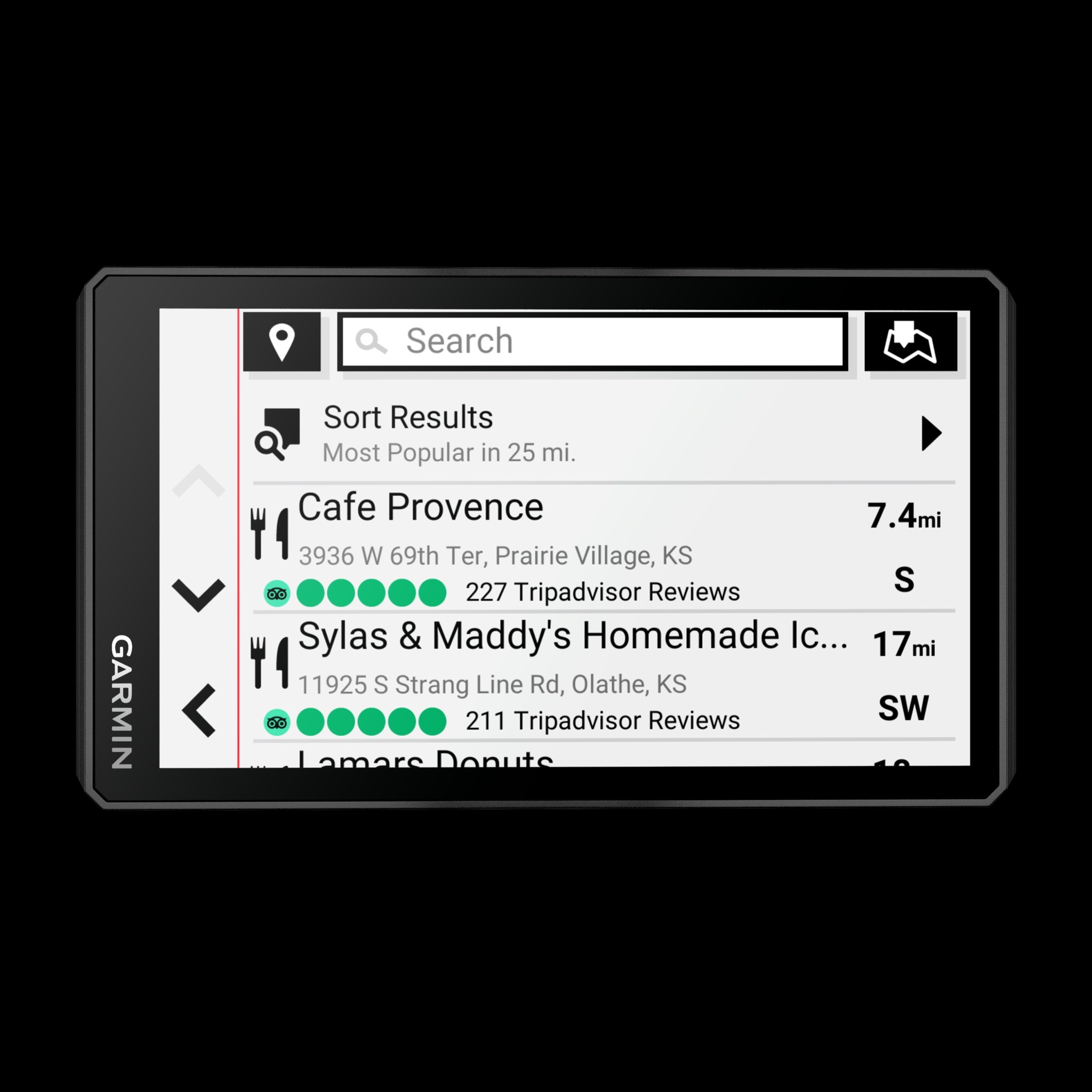
POPULAR PATHS
See popular moto paths ridden by other riders to find new and exciting routes to explore.
![]()
GARMIN ADVENTUROUS ROUTING
Straight roads are boring. Find the most thrilling routes with hills, curves and sights, and choose from 4 levels of difficulty.
![]()
RIDE SUMMARIES
Use the Tread app to review your ride details, including speed, acceleration, decelerations, elevation and more.
![]()
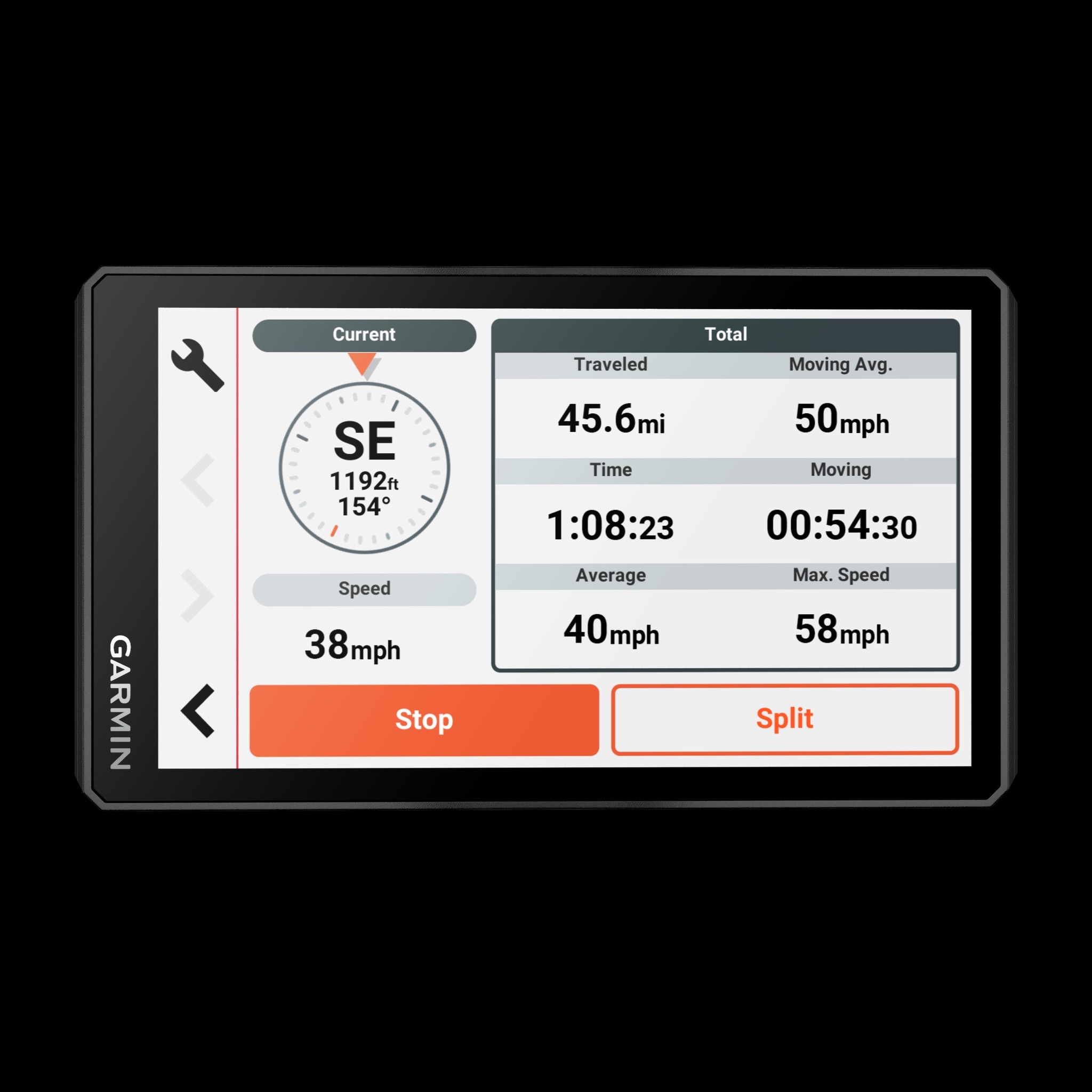
TRACK RECORDER
Record your ride data such speed, distance, acceleration and more and share the details with friends on Tread app.
![]()
SHARE YOUR FAVORITE ROUTES
Easily send GPX files from your phone or third-party sources to your zūmo XT2 navigator. Share GPX files with fellow riders by using the Tread app.
TRAVEL FEATURES
![]()
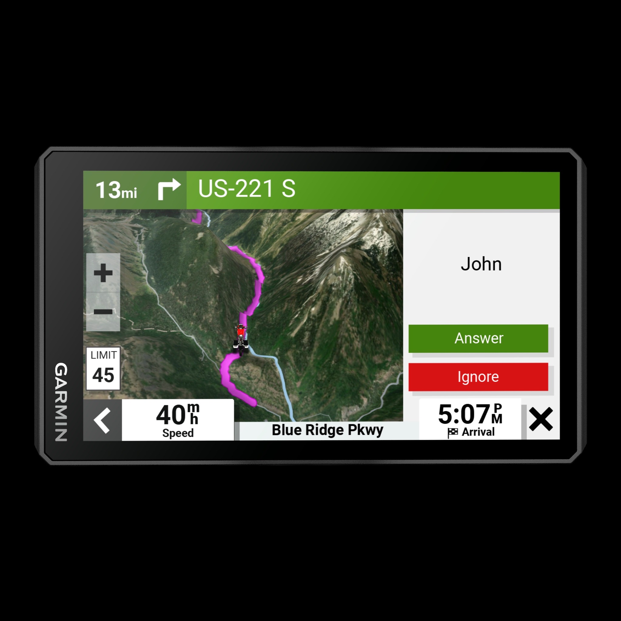
RIDER ALERTS
Get alerts for hazards along your route, such as upcoming sharp curves, speed changes and more. You’ll also be notified about state helmet laws and red light/speed cameras4.
![]()
MANAGE YOUR DATA
Easily manage5 tracks and routes across your navigator and compatible smartphone by using the Tread app.
![]()
MUSIC
Stream music from your smartphone through the zūmo XT2 navigator, or play MP3 files stored on the navigator — all to your connected helmet or headset.
CONNECTED FEATURES
![]()
WIRELESS UPDATES
Built-in Wi-Fi connectivity3 makes it easy to keep your maps and software up to date without using a computer. On-screen cues show when new updates are available.
![]()
LIVE TRAFFIC AND WEATHER
Access real-time traffic and weather, share routes with other riders, and get phone notifications via the Tread app5.
![]()
INREACH® COMPATIBILITY
Pair zūmo XT2 with a compatible inReach satellite communicator6 for two-way messaging, location sharing and, in case of emergencies, SOS capabilities.
![]()
BLUETOOTH® CONNECTIVITY
Hear turn-by-turn directions or stream music from your compatible smartphone through a connected helmet or headset.
![]()
INCIDENT NOTIFICATIONS
If an incident occurs, a text message with location information is automatically sent to your predetermined contact5.
![]()
CONTROL YOUR ACCESSORIES
Pair the zūmo XT2 motorcycle navigator with the compatible Garmin PowerSwitch™ digital switch box (sold separately) to enable on-screen control of your motorcycle’s 12-volt electronics.
Physical & Performance
| Display Size | 5.3″W x 3.0″ H (13.3 x 7.5 cm); 6″ diag (15.3cm) |
| Battery type | rechargeable lithium-ion |
| Display resolution | 1280 x 720 pixels |
| GPS | Yes |
| Dimension | 6.15″W x 3.5″H x 1″D (15.6 x 8.9 x 2.5 cm) |
| Weight | 12 ounces (340 g) |
| Display Type | multi-touch, glass, high brightness HD color TFT with white backlight |
| Battery life | up to 7 hours (up to 5 hours at 100% backlight) |
| Waterproof | IPX7 |
Maps & Navigation
| Navigate-a-track navigation | Yes |
| Preloaded street maps | Yes |
| External memory storage | yes (256 GB max microSD™ card) |
| Ability to add maps | Yes |
Features
| Ultimate Public Campgrounds | Yes |
| Visual route planner | Yes |
| Wi-Fi® map and software updates | Yes |
| Automatically identifies areas of biggest time gain | No |
| Parking Guard (alerts you to vehicle impacts) | No |
| Round trip routing | Yes |
| Speed limit changes | No |
| Speed limit indicator (displays speed limit for most major roads in the U.S. and Europe) | Yes |
| Max number of controllers* for pairing with a PowerSwitch device *Controller is defined by a user’s smartphone, mobile device or compatible Garmin navigator (sold separately) |
No |
| Magnetic Mount | No |
| Access to live services via app (traffic, weather, etc.) | Yes |
| Vault compatible (secure online video storage) | No |
| Interior and exterior recording | No |
| Rider alert warnings for sharp curves, state helmet laws, speed cameras and more | Yes |
| Preloaded private land parcel maps | No |
| Service History Log | No |
| Garmin Connect™ compatible | No |
| Current weather plus 5 day forecast via Wi-Fi | No |
| Simple truck profile | No |
| Trendy Places™ best stops along route | No |
| LiveTrack via app | No |
| RV Parks & Services directory | No |
| Group Ride Mobile | Yes |
| True Optimal Lap™ with video | No |
| Voice-activated navigation (operate device with spoken commands) | No |
| Built-in inReach® Technology (requires active subscription; subject to regulations or prohibitions in some jurisdictions) | No |
| Headphone jack/audio line-out | No |
| Control music and media from smartphone or MP3 player | Yes |
| Michelin® The Green Guide | No |
| Number of switch outputs | No |
| Route shaping through preferred cities/streets | Yes |
| Stream media and Alexa responses through vehicle stereo | No |
| Trucking points of interest | No |
| Requires cellular data connection | No |
| Driving performance scores | No |
| True Track Positioning™ (your racing line) | No |
| Wireless ANT+® technology | Yes |
| Segment analysis (racing line, speed and acceleration/deceleration) | No |
| Roadtrip Routes™ adventurous routes | No |
| Pair with compatible inReach® devices | Yes |
| Smart notifications via app | Yes |
| Truck & Trailer Services directory | No |
| Dust rating | No |
| Mile marker info – Trucking | No |
| Includes map updates | Yes |
| Barometric altimeter | No |
| Dual-orientation display | Yes |
| Planned & dynamic fuel stops | Yes |
| Includes traffic | yes (with Garmin Tread app) |
| Handlebar mount (up to 1″) | Yes |
| Fist mic compatibility | No |
| Compatible with external inReach® satellite antenna | No |
| Pitch and Roll gauges | No |
| Sunrise/sunset times – RV | No |
| BLUETOOTH® connectivity | No |
| Mile marker info – RV | No |
| Max number of PowerSwitch devices for pairing with a controller* *Controller is defined by a user’s smartphone, mobile device or compatible Garmin navigator (sold separately) |
No |
| State & country border notices – Trucking | No |
| Motorcycle or powersports specific points of interest for cycle repair services, dealers and more | No |
| Radio Frequency Band | compatible with Group Ride Radio |
| Compatible with the Garmin Tread app for route planning and data management (waypoints, tracks, and routes) | Yes |
| State border notices – RV | No |
| PrePass weigh station notifications and bypass decisions | No |
| Helmet law notifications | Yes |
| 2 microphones; beam-forming technology | No |
| Drop rating | MIL-STD-810 |
| Load-to-dock guidance | No |
| Track support | Yes |
| Turn-by-turn trail navigation | No |
| Radio transmitted canned messages | compatible with Group Ride Radio |
| Birdseye Satellite Imagery (download via Wi-Fi) | No |
| Internal storage | 32 GB |
| HOS violation warnings | No |
| 1″ ball adapter with AMPS plate | No |
| Data cards | microSD™ card (not included) |
| Built-in Alexa | No |
| Screw-down mount | No |
| Garmin Real Directions™ landmark guidance | Yes |
| Lane assist with junction view (displays junction signs) | Yes |
| iOverlander™ points of interest | No |
| Clarity ™ HDR | No |
| Max amps per switch output | No |
| Popular paths (Moto) | Yes |
| Sunlight readable and weather resistant | Yes |
| Group Ride voice communications | compatible with Group Ride Radio |
| Includes automotive mount | No |
| Supports multiple users | No |
| IFTA fuel logging capability | No |
| Local Spots™ nearby recommendations | No |
| Stores history of all on-track performance | No |
| Incident messaging | No |
| Group Ride update rate | No |
| Preloaded topographical maps | Yes |
| Number of hardwire inputs | No |
| Track recorder (breadcrumbs) | Yes |
| Preloaded USFS Roads and Trails, including motor-vehicle-use-maps for motorcycle, ATV, SXS and full-size 4×4 | No |
| Live view from anywhere (Vault LTE subscription required, LTE coverage-dependent) | No |
| VIRB® control | No |
| GLONASS | No |
| Downloadable Satellite Imagery | yes (BirdsEye) |
| Preloaded global track database | No |
| TripAdvisor® Traveler Ratings | Yes |
| Group Ride tracking | compatible with Group Ride Radio |
| Built-in Spotify® & Pandora® music players | No |
| Removable battery | No |
| Audio line-out/headphone jack | No |
| Live View (Wi-Fi® connection required) | No |
| Garmin Adventurous Routing™ | Yes |
| Glove-friendly touchscreen | Yes |
| High Definition 3D terrain | No |
| Dog tracking | No |
| Powered magnetic mount | No |
| BirdsEye Direct Satellite Imagery | Yes |
| Session comparisons | No |
| BLUETOOTH® pairing | yes (works with BLUETOOTH-compatible helmet, headset or smartphone. BLE capable.) |
| Elevation profile | Yes |
| Custom map support | Yes |
| Sunrise/sunset times – Trucking | No |
| 3D Terrain | Yes |
| Compatible with Group Ride Radio | yes (6″, 8″ and 10″) |
| TOPO map support | Yes |
| Point-to-point navigation | Yes |
| 1.5″ ball adapter with AMPS plate | No |
| Millions of Foursquare® points of interest | No |
| Tube mount (1.5″ – 2.375″) | No |
| Built-in accelerometers | No |
| Interior night vision | No |
| GPS speed and location info in video | No |
| Built-in dash camera with automatic incident detection | No |
| Unidentified driver alert | No |
| Driver alerts for sharp curves, school zones, red light and speed camera warnings and more | Yes |
| Preloaded US public land boundaries | No |
| Compatible with external GPS antenna with mount | No |
| Camera-assisted features for forward collision warnings, lane departure warnings and “Go” alert. | No |
| Real-time audio cues/audio coaching | No |
| Displays best lap time, adaptive delta time, number of laps and total session time | No |
| Supports multiple cars | No |
| Downloadable USGS Quad Sheets | No |
| Max amps total | No |
| 10 Hz multi-GNSS positioning | Yes |
| Pair with Garmin PowerSwitch™ digital switch box | Yes |
| Easy Route Planner with GPX file sharing | No |
| Compass | No |
| Compatible with Garmin Explore™ app | No |
| Galileo | Yes |
| Truck-specific speed limits | No |
| Incident Detection (G-Sensor) | No |
| Exterior night vision | No |
| Popular truck route data | No |
| 3-D buildings and terrain | No |
- zūmo XT2
- Motorcycle mount and hardware
- Motorcycle power cable
- USB cable
- Documentation
Bundle
- zūmo XT2
- Group Ride Radio (6″, 8″ & 10″)
- Group Ride Radio Y-adapter
- Motorcycle mount and hardware
- Motorcycle power cable
- USB cable
- Documentation


Reviews
There are no reviews yet.